- 12 days
- 5160m
Manaslu Circuit with Tsum Valley Trek is an interesting and exciting adventure around the Far North Mid-West of Nepal and within the remote wild country of the northern areas of Gorkha district, where we have combined both the best of the region of the central Himalaya.
The trek leads you to the most fascinating and wildest region where you will be incomplete ambience within the pristine and hidden valley of Tsum, which the native knows by the ancient Tibetan name as “Beyul Kyimolung”, which means Valley of Happiness.
Tsum Valley will be our first visit, which is east of the Manaslu area and behind the massive bulk of Ganesh Himal, also known as Yangri in the local language of Tsum and the Manaslu region.
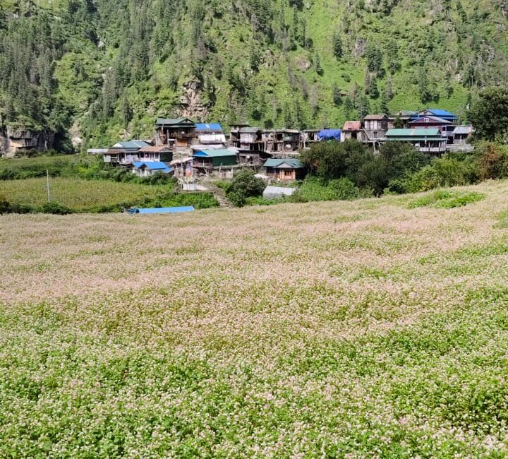
The walk leads after a great long and interesting drive from the capital Kathmandu to reach low warm areas around heavy agricultural farm villages of Gorkha district at Arughat town, and then starting walks from Soti-Khola village, where the walk follows on the same trail of the Manaslu route, past Jagat and Philim to reach the first village of Tsum at Chumling.
From Chumling enter into the windswept territory to reach the remote and impressive villages of Chokan-Paro with Ni-le having an exciting time facing outmost views of high snow-capped peaks then reaching our first highlight of the adventure on reaching Mu Gompa, a place with old monastery enriched with ancient artifacts and tall idols of Lord Buddha and other famous Gurus.
Enjoying marvellous moments where the walk leads to visit another nice village of Rachen with its monastery, which is worth visiting before joining our treks on the main trail of Manaslu at Lokpa and Namrung villages.
The adventure leads behind the great Tsum Valley of happiness as the walk enters the main wide trail of Manaslu with a superb panorama of the Manaslu range of peaks as the journey continues from one place to another to reach a major village in Sama-Gaon situated on the route to Larke-La pass and towards Manaslu base camp.
At Sama-Gaon, explore local cultures and the interesting traditional life of Manaslu villagers, where the walk leads to the valley rim of Manaslu, and the next morning, climb high to the top of Larke-la pass with the overwhelming panorama of surrounding great peaks.
Slowly, the walk leads to a long descent back into green lush vegetation with tall trees of rhododendrons and pines at Bhimthang a wonderful spot within the forested surroundings and then downhill to reach Dharapani village, where the walk completes, taking a drive back to the low warm area at Besisar headquarters town of Lamjung district.
From Besisahar, a scenic and exciting overland brings you to Kathmandu to conclude our most remarkable and fascinating adventure with an awesome experience on the Manaslu Circuit and Tsum Valley Trekking.
From March to May and September to early November are months of the year to days are longer with sunlight hours till late afternoon, with clear days for excellent views of snow-capped peaks and pleasant walks, but can get cloudy with light rains and can snow on higher elevations sometimes.
March to May, when hills are alive with seasonal wild flowers in bloom, especially rhododendrons of various species from tall trees to a bush, September to early November is another best time for clear views of peaks and walks, but with shorter days and sunlight hours due to the autumn or fall season.
Much colder nights and mornings, including around shades, can sometimes snow around higher hills with more freezing temperatures, with chances of snow on the Larke-La pass.

Trekkers camping in Dharmsala during the trek
From mid-November onward, the Tsum and Manaslu villagers migrate to low, warm areas to escape the cold and harsh winters, where most villages will be deserted and lodges will be closed from November onward till March and April.

Manaslu Tsum Valley trek outline itinerary
On fresh arrival at Kathmandu and Nepal international airport received by staff and a guide with a short transfer into the hotel.
In the evening group welcomes dinner in a nice authentic Nepalese restaurant with a cultural program to give you a glimpse of local culture with music and dance while having your dinner.
On this day, we will embark on a journey to the Upper Valley, situated near the inner Himalayas. The route follows the Syar river to Domje, the largest settlement in this region, where our climb to Chhokkangparo commences. On a clear day, Chhokkangparo presents breathtaking views of Himalchuli and Ganesh Himal. During our stay in Chhokkangparo, you will have the opportunity to experience the warm hospitality of the Tsombo community, complemented by Tibetan tea (butter tea) and traditional local cuisine.
Arriving at Machha Khola, situated at an elevation of around 870 meters, marks the official entry Point to the lower Manaslu region, a crucial step for your trek. This charming village, nestled by the Budhi Gandaki River, provides a tranquil evening to rest and prepare for the upcoming days of trekking.
The journey highlights the diverse topography of Nepal from bustling cityscapes to the tranquil foothills of the Himalayas. Get ready to experience the authentic charm and honest beauty that awaits you on this unforgettable Manaslu circuit with the Tsum valley trek.

trekkers resting on the way
We traverse the Tharo Khola River and proceed upstream to Khola Besi. The path takes us along the striking gorge, featuring waterfall-carved rocks and areas impacted by landslides. Upon crossing the bridge, we will arrive at the small village called Kholabesi, followed by the natural Hot Springs.
We will then take another trail from the Hot Springs to cross the Budi Gandaki River on a suspension bridge. We will then continue past a landslide to reach Dovan village.
From dove on, we will cross the suspension bridge over the Yaru Khola and ascend the stone steps to Thado Bharyang before climbing up to the delightful town of Jagat, which serves as a gateway to the Manaslu Conservation Area, where we will register the permit at the checkpoint.
trekker from Jagat on the way to Lopka
We entered the restricted area of Manaslu by ascending a route to reach Salleri. Following the riverbanks, crossed the Budi Gandaki River via a long suspension bridge. As we proceed, the valley opens, leading to the Philim. Just past Ekle Bhatti, the path diverges: one route leads to Tsum, while the other heads towards Manaslu.
We make our way upwards, Lokpa, traversing several villages along the way. The river’s narrow, and we’ll catch a glimpse of the confluence of the Yar rivers from the Tsum Valley. Travelling along the right side of Tsum Valley, we arrive at Lokpa village, the first settlement in Tsum Valley that offers these stunning views of the Manaslu range.
This valley, a hidden gem blessed by Padma Sambhava centuries ago, who was regarded as one of the founders of Tibetan Buddhism, provides a breathtaking view of Himalchuli and Boudha Himal from Lokpa village.
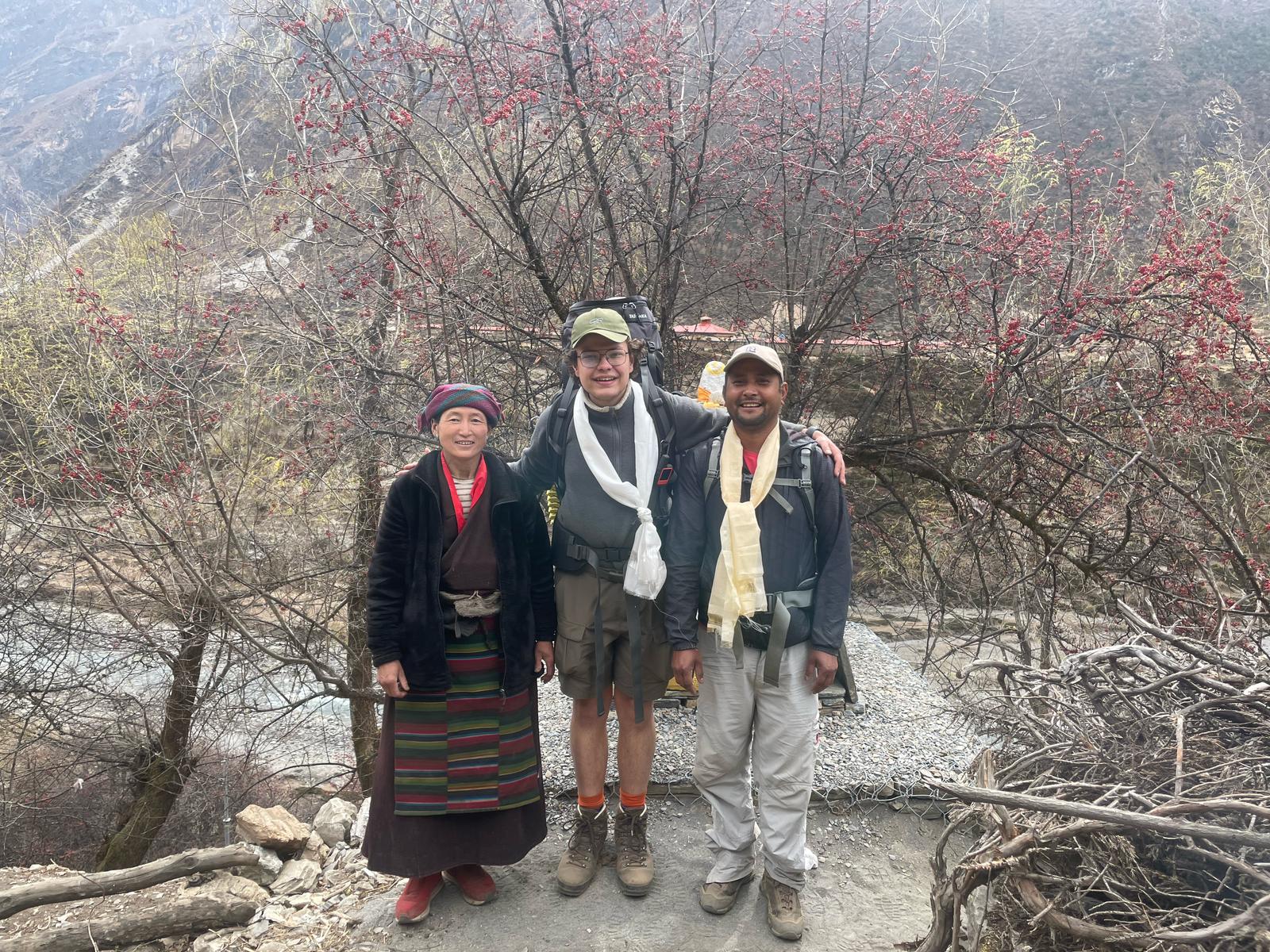
Trekker with guide and local woman
Following breakfast, we will embark on our trip to Lokpa village, which serves as a rugged gateway to the Tsum Valley. On a clear day, the views of both the Himalayan Ganesh himal are breathtaking along the path leading from Lokpa to Chumling.
Our route initially descends into the Lungwa River Valley before climbing through a dense subtropical forest filled with rhododendron and Pines. There are no settlements between Lokpa and Chumling.
We will cross the Syar Khola to reach Chumling. A detour to the upper section of Chumling leads to the monastery that offers magnificent views of the Ganesh Himal. Chumling is home to the Health Post and three monasteries. Pango Gumba, Mani Dhungyur and Gurwa Gumba.
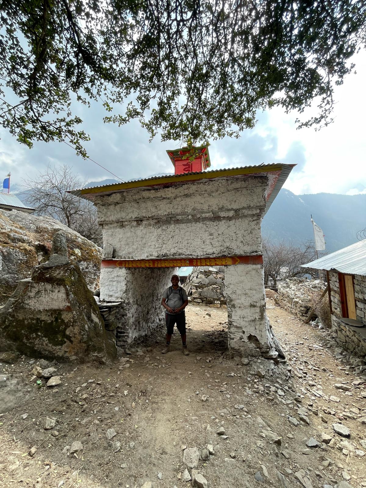
Entry point of Chhokang Paro
On this day, we will take a trip to the Upper Valley, located within the vicinity of the Inner Himalayas. The trail traces the Syar river to Domje, the Largest town in the Tsum valley, from where our ascent to the Chhokang Paro begins.
On a clear day, Chhokangparo offers stunning views of both Himalchuli and Ganesh Himal. While in Chhokangparo, you will have the chance to experience the warmth of hospitality provided by the local Tsombo people, after enjoying the Tibetan tea (butter tea) and traditional local dishes. After replenishing your energy with a delightful Tsombo hospitality, the day continues with further exploration of this pristine region.
You will have the opportunity to visit ancient monasteries and observe the unique Buddhist culture that thrives in the Tsum valley, a truly enriching experience. The serene atmosphere and panoramic vistas surrounding Chhokangparo make it an ideal spot for reflection and photography.
Prepare yourself to be captivated by the spiritual aura and the untouched beauty of the Upper Tsum Valley, solidifying unforgettable memories of your trek.

Monastery on the way to Milarepa
Today, we’ll be travelling a relatively short distance. The Nile, situated on the western side of Shiyar Khola, is about a 20-minute walk from Chhule, the last village in the northern upper Tsum valley.
Upon your arrival at Ngakyu Leru, you’ll see natives of the region farming on the fertile land of the region. After passing through Lamagaon, you’ll come to St. Milarepa Piren Phu cave, known for preserving a footprint of the saint in the rock.
This cave, referred to as the pigeon cave, is one of the Tsum Valley’s most sacred locations. Inside you’ll find two distinct gumbas, vibrant Buddhist murals with intricately carved scripts on stones, long prayer flags, and important Buddhist texts, which all contribute to its status as a vital cultural treasure of the valley.
From there, we’ll cross a suspension bridge over the Shiar River and continue the trip through several villages until we reach the Nile.
This segment of your Manaslu circuit with Tsum Valley Trek promises a deeply spiritual and visually stunning ascent from the Nile to the revered Mu Gompa. Starting your day on the Nile, it is approximately 3361 metres, you will embark on a steady at manageable uphill journey covering roughly 6 kilometres over three to four hours.
As you trek, the lush valley gradually gives way to the more barren high Alpine landscapes reflecting the proximity to the Tibetan Plateau. This transition in scenery, coupled with increasingly expensive views of the majestic ranges, offers a profound sense of remoteness and grandeur, truly immersing yourself in the heart of Upper Tsum Valley.
Your destination, Mu Gompa, stands majestically at 3700 metres, representing the highest settlement in the Tsum pivotal cultural landmark on your Manaslu circuit with the Tsum valley trek. This ancient monastery serves not only as a place of worship but also as a repository of historical artefacts and Buddhist traditions, with a palpable sense of peace pervading its grounds.
Upon arrival, you’ll have ample time to explore the monastery, observe unique customs at the local Tsumba people and observe the serene ambience of this sacred site, feeling the strong cultural echoes of Tibet.
This tranquil evening at Mu Gompa provides an unparalleled opportunity for contemplation amidst the dramatic Himalayan backdrop, making it a highlight of your entire journey.
On day 9 of your Trek, you’ll embark on a rewarding trek from the Nile to Lamagaon, culminating in a significant visit to the ancient Rachen Gompa, situated at 3,240 meters. Departing from the Nile (approx. 3,361m), the trail involves a descent, allowing you to gradually shed altitude while still enjoying the vast openness of the upper Tsum Valley.
The five-hour journey offers diverse scenery as a transition from the more barren landscapes and surroundings of Mu gompa and back into the areas with more visible greenery and traditional settlements, providing a rich tapestry of the region’s natural beauty.
The highlight of this day is undoubtedly the visit to Rachen Gompa, a prominent Buddhist nunnery, uniquely positioned on the boundary between Nepal and Tibet, surrounded by enormous, awe-inspiring mountains.
This spiritual hub provides a deep insight into the lives of Buddhist nuns and their devotion, offering a different cultural experience compared to the monasteries that you may have visited earlier.
After you explore Rachen Gompa, you will continue your trip through the charming forest sections, eventually arriving at the welcoming village of Chokkang Paro at approximately 3030 metres.
Here today, you are once again rewarded with breathtaking views of both Humalchuli and Ganesh Himal. This day beautifully combines cultural discovery and scenic trekking, making it a memorable part of your trek.
Your trek involves a significant and scenic descent from the beautiful village of Chhokang Paro (3,031m) to the welcoming settlement of Chumling (2386), A journey expected to take approximately 6 hours.
Leaving behind these spectacular views of Himalchuli and Ganesh Himal, your path will lead through a variety of regions as you steadily lose altitude.
You’ll pass through small villages of Gho, continuing your descent that offers a refreshing change in both landscape and temperatures, moving from the more exposed upper valley to a greener, more temperate zone.
As you progress towards your destination, that trail guides you past the traditional Tsumba villages and over an exciting suspension bridge, providing a sense of adventure inherent to the trek.
You will pass through Rainjam village before finally arriving in Chumling, A charming and relatively larger village known for its beautiful stone houses and terraced fields.
This day provides a well-deserved opportunity to relax and lower elevation, reflecting on unique cultural encounters and breathtaking natural beauty experienced in the upper reaches of the Tsum Valley.
As your trek begins its return journey towards the main Manaslu trail, Day 11 sees you trek from the tranquil village of Chumling (2,386m) to the quaint settlement of Lokpa (approximately 2,240m). This segment largely involves a descent, guiding you through a changing landscape of cultivated fields, scattered hamlets, and dense forests.
The path generally follows the Siyar Khola, leading you back towards its confluence with the Budhi Gandaki, marking a clear transition from the inner Tsum Valley back to the primary Manaslu route.
The trek to Lokpa, typically taking around 4 to 5 hours, offers a chance to reflect on the unique cultural and natural experiences of the Tsum Valley, as you reconnect with the main trail of the trek.
Lokpa itself is situated just at the entry point of the Tsum Valley restricted area, providing a different perspective from when you passed through it earlier in your journey. This day is a pleasant blend of continued scenic beauty and a gradual transition to lower altitudes, setting the stage for the next phase of your Himalayan adventure.
Returning to the main trek route, your journey from Lokpa (approximately 2,240m) to Deng (approximately 1,860m) marks a notable shift in altitude and environment. This day involves a generally descending and undulating path, typically taking around 5 to 7 hours to complete.
As you leave the direct access point of the Tsum Valley, the trail once again immerses you in the dramatic Budhi Gandaki river gorge, characterised by its deep valleys, lush forests of rhododendron and pine, and impressive waterfalls that cascade down the steep hillsides.
The trek to Deng is a fascinating blend of natural beauty and cultural transition. You’ll navigate through dense bamboo and rhododendron forests, often crossing the Budhi Gandaki River on sturdy suspension bridges that offer thrilling perspectives of the roaring river below.
Upon arrival in Deng, a charming village with distinct Tibetan cultural influences, you’ll notice a subtle change in the architecture and the local dialect as you re-enter the main Manaslu trekking corridor.
This day on your trek perfectly showcases the diverse landscapes and cultural richness that define this incredible Himalayan adventure.
Continuing your captivating trek, day 13 (assuming consecutive day numbering) sees you trek from Deng (approximately 1,860m) to the picturesque village of Namrung (approximately 2,630m). This segment marks a significant ascent, as you gain considerable elevation over a trek typically lasting 6 to 7 hours.
The trail initially leads through lush forests, crossing the Budhi Gandaki multiple times on impressive suspension bridges, before gradually transitioning into a more arid, high-alpine landscape with increasing views of the surrounding peaks. You’ll pass through several small settlements like Rana and Bihi, where the cultural influence of Tibetan Buddhism becomes even more pronounced.
Upon arrival in Namrung, a charming village with traditional stone houses, you’ll feel a distinct shift in the atmosphere and witness the vibrant Tibetan culture firsthand.
Namrung is often considered the gateway to the upper Manaslu region, and on a clear day, it offers your first truly spectacular views of the towering Sringi Himal, a thrilling preview of the grand mountain scenery to come on your Trek.
This day’s strenuous climb is rewarded with increasingly breathtaking vistas and a deeper immersion into the rich cultural tapestry of the Himalayas.
Day 14 of your trek brings you closer to the heart of the majestic Himalayas as you trek from Namrung (approximately 2,630m) to the enchanting village of Lho, often referred to as Lo Gaon (approximately 3,180m).
This rewarding segment typically takes around 4 to 5 hours, offering a steady ascent through traditional Tibetan villages. As you climb, the landscape opens up dramatically, revealing increasingly spectacular panoramic views of the colossal peaks that define the Manaslu region.
The cultural immersion deepens on this day as you pass through villages adorned with intricately carved mani walls, chortens, and impressive Kani gates, all testaments to the strong Buddhist heritage.
Upon arrival in Lho, prepare to be awestruck; on a clear day, the village offers one of the most stunning, close-up views of Manaslu (8,163m) itself, along with Himalchuli and Ganesh Himal.
Lho also hosts a large monastery, adding to the spiritual ambience, making this day a true highlight of your trek, blending magnificent mountain vistas with profound cultural insights.
Today, on our trip, as we move forward, we’ll come across a variety of attractions incorporated and fused with traditions. As our trip keeps going, we’ll take a hike across the terraced fields beside the mani-walls.
We’ll also go across the wooden crafted bridge over the Budhi-Gandaki River that’ll eventually lead our trail to a beautiful valley named Samdo.
A walk continues crossing a few icy streams to reach Larke Phedi means the bottom of the pass, also known as Dharmasala means ‘travelers’ rest house/shade’, where in early days also called Larke Bazaar, (where trade and bartering were held between merchant-traders of Gorkha-Manaslu-Manang people and Tibetans on this remote isolated spot).
At Larke, Phedi afternoon is free for short walks and preparations for the next early morning long climb and descent crossing the high Larke-La pass to reach the Manang area.
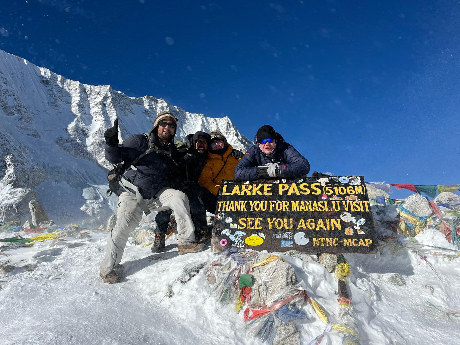
Trekkers on Larke-la pass
From the top of Larke-La panorama of Himlung, Cheo Himal, Kang Guru, and Annapurna II include a series of Manaslu peaks, and then descend back into tree lines through Larcia, as walks lead on the moraine ridge to Tambuche at the bottom of Larke-la pass, where a short walk takes you to Bhimthang for overnight.
Bhimthang is a wonderful spot situated on a wide green valley with several lodges adorned with prayer Mani walls, surrounded by green tall trees of rhododendron, pines and oaks.
Walk into a beautiful forest to reach a small clearing in the middle of a forest at Ghoa for an overnight stop, a cattle and yak herders’ summer pasture with a temporary settlement.
After Gho, today will be the last day of the adventure on reaching the large Dharapani village as the walk follows the downhill trail through the forest to reach a nice village at Tilje village, a nice place by the raging Marysangdi River.
From Tilje shortstop climbs for a short while after crossing over a bridge to reach the nice village of Dharapani, located at the junction of the popular Annapurna and Manaslu circuit route, in the district of Manang.
After a refreshing break at Dharapani drive following the Marsyangdi River downstream to reach a low warmer farm area and a large area of Besisahar, a headquarters town of Lamjung district, with overnight stops in a nice lodge and hotels.
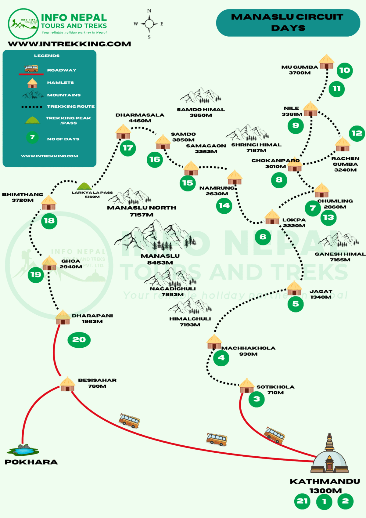
This map outlines a detailed itinerary by Info Nepal Tours and Treks. It presents a multi-day trip through the Nepalese Himalayas, indicating roadways, hamlets, mountains, and the trekking route. The numbered sequence marks the progression of days, typically commencing from Kathmandu and concluding in Pokhara, illustrating a complete circuit.
The trek begins with travel from Kathmandu to Soti Khola, then proceeds through Manaslu circuit points like Machha Khola and Jagat. It then branches into the Tsum valley, visiting culturally significant areas such as Chumling, Nile, Mu Gompa, and Rachen Gompa, before rejoining the main Manaslu trail near Namrung.
The Map highlights the high-altitude segment, including Sama-Gaon, Samdo, Dharamshala, and the challenging Larkya La pass (5,150m), culminating in a descent to Bhimtang and eventual connection to Pokhara.
The trip offers you beautiful vistas during the trek, which will be a unique experience for many travellers. You can capture photos and create lifelong memories while exploring the sites. In addition to that, you’ll be accompanied by well-experienced, friendly and qualified guides who’ll be sharing information and knowledge about the regions with you, along with porters who’ll help you with your luggage. You’ll be expected to carry small backpacks that might hold your valuable belongings.
A typical day starts with a hot cup of coffee/tea afterwards, we’ll set off for our trip of the day. We’ll be hiking for 3-4 hours, depending on the nature of the day and its atmosphere. Upon the completion of the 3-4 hours of the trip, around the middle of the day, we’ll have lunch while on the trail to the next point.
Upon reaching the overnight accommodation point, we’ll unwind and get some rest, followed by brief site explorations in the locality, and upon returning, dinner will be served. Post-dinner, you can talk about the experience of the day with the guide or the trip leader. In the meantime, you can also plan for the trip of next day with the leader, as the leader will brief you about the next day’s program.
Water and electricity supplies are available throughout the region. But during the trip, it’s advised for foreigners to have their personal water bottle or mineral water as their bodies might not have well adapted to the water from the new environment, whereas for the electricity, it might incur additional cost to recharge their mobile and other electronic devices.
Sometimes mineral water bottles might not be available right away, with the only option for local tap water, and to make it suitable for your gut, it’s advised that you rather have some purification tablets.
During the trip, you’ll get access to internet services here in Kathmandu without any hassle, but while on the route or in the teahouse or lodge, you might have to bear an extra charge. With the rising elevation of the trip, the internet gets out of reach, leaving only the phone as an option.
The talk with fellow teammates will be at least once a day to ensure safety and get the update, but keep in mind that mobile signals might not even be available to have many or long talks.
You can also buy a SIM card that costs just $1 from any local communication service operator or mobile phone service centre, for which you might need to provide a 1-page-sized photo and a copy of your passport.
As for the data-acquiring process, the manual comes along with the package of SIM cards.
The best time for visiting is from March to May and from September to November.
March-May (spring)
Early March is considered one of the best for the view of mountains and regional glaciers as bright as daylight. The temperatures gradually start plummeting, gently leading to clear skies and, as mentioned prior, giving off the best views of snow peaks when snow is still intact, along with the beautiful views of vibrant rhododendrons but by the end of March, snow might fade away.
September- November (Autumn)
This is also a great season and time of the year to pay a visit to Manaslu, as it’s the peak of the tourist season due to the great weather and atmosphere it offers compared to other times of the year. This is also the most vibrant duration as it comprises multiple festivals in Nepal, allowing you to witness the unique and different cultures you might get to witness for the first time in your life.
Festivals like Dashain, Tihar and Chhat give out a great vibe that will make you feel vibrant everywhere you go.
As for the passport and visa, you can get an on-arrival visa at the TIA and for Indian nationals, they don’t require any sort of visa but rather a valid identification document to get to Nepal.
As for the nationals required to have a visa, a visa application is required with at least six months of validity, a passport-sized photo and visa charges. Citizens of SAARC nations will be granted free visas. Since it’s a government-based regulatory work, the policy might change even without advanced notice. So, to be updated, you can visit the site for visa information, click here:
All travellers must have travel insurance as situations like natural causes such as landslides, avalanches, altitude sickness, and many other unforeseen events might strike out of the blue. In case of emergencies, an airlift might be required, which will be covered frobyur insurance and should be enough to do so.
($1=130 NPR)
Foreign currencies aren’t directly valid in Nepal, so you can exchange them for Nepalese currency in your hotel or at any currency exchange centres. Besides Nepalese currencies, only Indian currencies are valid.
The trip to Tsum Valley and the Manaslu circuit is a strenuous one. We’ll be exploring the pristine portion of the region and getting time to unwind for a while for a day before heading to Larky la Pass to get to the Manaslu circuit. At the beginning of the trip, it’ll be easier as we’ll be starting from lower elevations, gradually leading to higher comprised of a steep descent and long climbs on the road, which might be physically challenging.
Travellers with past hiking experience will have some advantages due to their adaptability. Travellers with conditions like COPD and respiratory issues are advised and requested to be informed about it in advance.
“Manaslu Circuit with Tsum Valley Trek is an extended trekking adventure in the Manaslu region of Nepal, combining the classic Manaslu Circuit route with a spiritual and cultural detour into the remote Tsum valley.